

The Past Matters: Lessons From History and From Japan’s March 11 Earthquake and Tsunami
Lori Dengler and Gregory Smits with Yale Environment 360 and the Asia-Pacific Journal.
This four part article introduces geophysicist Lori Dengler’s assessment of Japan’s March 11 Tohoku Earthquake and Tsunami, and its lessons for Japan and the world. It includes: an introduction by Gregory Smits, an interview with Yale Environment 360, a note by Dengler summarizing her ten day site visit to Japan beginning April 30, and an interview with The Asia-Pacific Journal.
It is my pleasure to introduce the interview with Lori Dengler, “Tracking the Destructive Power Of the Pacific Ocean’s Tsunamis,” conducted by Yale Environment 360 on March 22, 2011, eleven days after the March 11 Tohoku Earthquake and tsunami. Having become aware of this interview recently, I was struck by the substantial degree to which the interview complements my article, “Danger in the Lowground: Historical Context for the March 11, 2011 Tohoku Earthquake and Tsunami.” Here I will briefly discuss some points in the interview that struck me as especially noteworthy.
First I would echo the interviewer’s point that although the nuclear power plant failure is obviously a matter of great concern in both Japan and other parts of the world that rely on nuclear power, we should not lose sight of the awesome geological event that took place, which also has implications that go beyond Japan. The death toll from the recent tsunami is now approaching 25,000.
As Dengler points out, the 1923 Great Kanto Earthquake was many times more deadly than the recent tsunami, despite being of much lower magnitude. Its location and the nature of local conditions (dense urban area, just before noon, windy day, et cetera) are what made it so deadly. The magnitude of an earthquake, while obviously important, is not necessarily the crucial element in determining how deadly or damaging a seismic event will be—especially in the case of tsunami earthquakes, of course. It is mainly for this reason that in my article, I mention that the recent earthquake exceeded expert expectations in terms of magnitude, but I did not regard that point as particularly important. More significant in practical terms was the size of the tsunami, which was roughly the same as 1896.
My lack of concern that experts did not anticipate an M9-class event was, of course, also a function of my being an historian, not a seismologist. Writing in a recent issue of Nature on the general topic of “rebuilding seismology,” Takeshi Sagiya of Nagoya University struck an apologetic tone. He pointed out that while he and other experts were aware of a high probability of a magnitude 7.7–8.2 event in that area, nobody imagined an M9-class event despite two important pieces of evidence. One was the recent geological evidence of a massive tsunami inundating the Sendai Plain in 869, which Dengler also discusses. The other evidence was that GPS data shows that in the Japan Trench the ratio of cumulative fault slip to plate motion (seismic coupling coefficient) in large earthquakes has been only around 30%, and it has been impossible to account for the other 70%. That large remainder, combined with the historical/paleoseismological data, point to the potential for much larger events. Sagiya’s conclusion is that seismologists must consider all the data, historical and geological, and not overlook inconsistent data.
The evidence dating to 869 is a sand sheet. Dengler also discusses the importance of sand sheets and points out that they extended further inland than the historical record indicates. She also reports that some seismologists have discussed the possibility of M9-class events based on that evidence. I might add that historical evidence from the 1611 tsunami (almost certainly the result of a tsunami earthquake, as in 1896) clearly indicates a more extensive reach of tsunami waves than occurred either in 1896 or 2011. Also of interest, recent research presented on May 15, 2011 indicates that a massive tsunami on a par with the 869 event (now regarded as a likely M9-class earthquake) took place 2000 years ago during the Yayoi period. The article concludes that these massive events likely occur in a cycle of about once every 1000 years. Even if the 1000-year cycle is accurate, the 1611 and 1896 events were probably even more dangerous owing to the lack of severe shaking. Moreover, the 1933 Showa Sanriku Earthquake and tsunami should be a reminder that sub-M9 earthquakes and tsunamis in the region are also deadly and much more common.
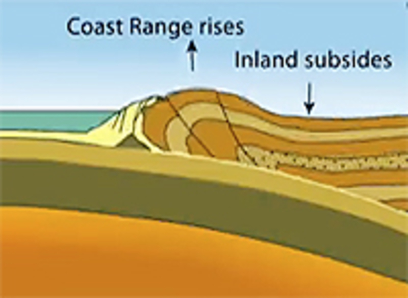
Dengler’s interview is a delight to read owing to the clarity with which she explains relevant geologic phenomena. Her discussion of the area along the coast of the United States and Canada subject to the same general danger as Japan’s Tohoku region explains in some detail how Brian Atwater and others used data from submerged forests of Red cedars to match written documents in Japan to help date the 1700 earthquake and tsunami. Dengler’s discussion of factors making the North American zone less dangerous (e.g., fewer people living at the coast) again points to the importance of local conditions in either amplifying or mitigating natural hazards.
In short, the record of the past, including historical documents and paleoseismological data, is an invaluable tool for assessing earthquake and tsunami hazards. Moreover, the record of how people have reacted to major disasters is similarly valuable in devising strategies for mitigating such events in the future.
Tracking the Destructive Power Of the Pacific Ocean’s Tsunamis:
The devastating tsunami in northeastern Japan is only one of many that have battered Japan over the eons. In an interview with Yale Environment 360, tsunami and earthquake expert Lori Dengler describes the historic and paleological record of tsunamis across the Pacific, and what it may mean in the future for Japan and the western United States. Interview conducted March 22, 1011.
Geophysicist Lori Dengler of Humboldt State University in California has traveled the world studying the impacts of tsunamis and working with governments to mitigate their wrath. Earlier this year, just weeks before the recent Japanese earthquake and tsunami, Dengler was in Tokyo, attending a meeting of Japanese port officials interested in better preparing for the tsunamis that will inevitably strike their earthquake-prone nation.
Even years of visiting regions struck by tsunamis, such as the massively destructive Indian Ocean tsunami of 2004, did not prepare Dengler for the images of entire Japanese towns being obliterated by a 30-foot wall of water. Not even Japan, with its unsurpassed preparedness, could escape the destruction of a 9.0 earthquake and tsunami that has taken the lives of 10,000 to 20,000 people.
 Lori Dengler |
In an interview with Yale Environment 360, Dengler describes the long history of Japanese tsunamis, including an 1896 tsunami that killed 22,000 people in the same region as the recent disaster. The prehistoric record, Dengler explains, contains evidence of even more powerful tsunamis in Japan and along the western coast of North America — warning signs that nations across the Pacific rim need to further bolster their preparations for tsunamis. Referring to the scale of the latest tsunami, Dengler said, “It’s very humbling, and I’m not going to predict what Mother Nature will do next. But let’s just say that she holds all the cards.”
Yale Environment 360: Given all of the attention that has rightly been paid to the unfolding nuclear crisis in Japan, it almost seems as if we’ve lost sight of what an extraordinary geological event this was. Could you put this sequence in historical perspective?
Lori Dengler: Certainly big earthquakes and great tsunamis are no strangers to Japan. Japan has a long and tragic history with both, and the location of this event was really no surprise at all. We call it the Sanriku Coast of northeastern Honshu, and a number of very tragic events have occurred in that area, including the Meiji-Sanriku tsunami of 1896, when an estimated 22,000 people died. The highest water heights in that event approached 90 feet, in Iwate Prefecture.
So none of us [earthquake experts] were surprised by the location. What was certainly surprising was the size of this earthquake. When you look at Japan’s historic record of tsunamis, they’ve been generated by earthquakes that are in the magnitude 8 to 8.5 range. This was very clearly the largest magnitude earthquake recorded since we’ve had modern seismographs since 1900. The giant Tohoku District earthquake in 869 may have been close to this in size. There are certainly some people saying that this event was much larger than what the Japanese had been planning for. A magnitude 9 earthquake is 30 times more energetic than a magnitude 8, and more important are the dimensions of the fault rupture.
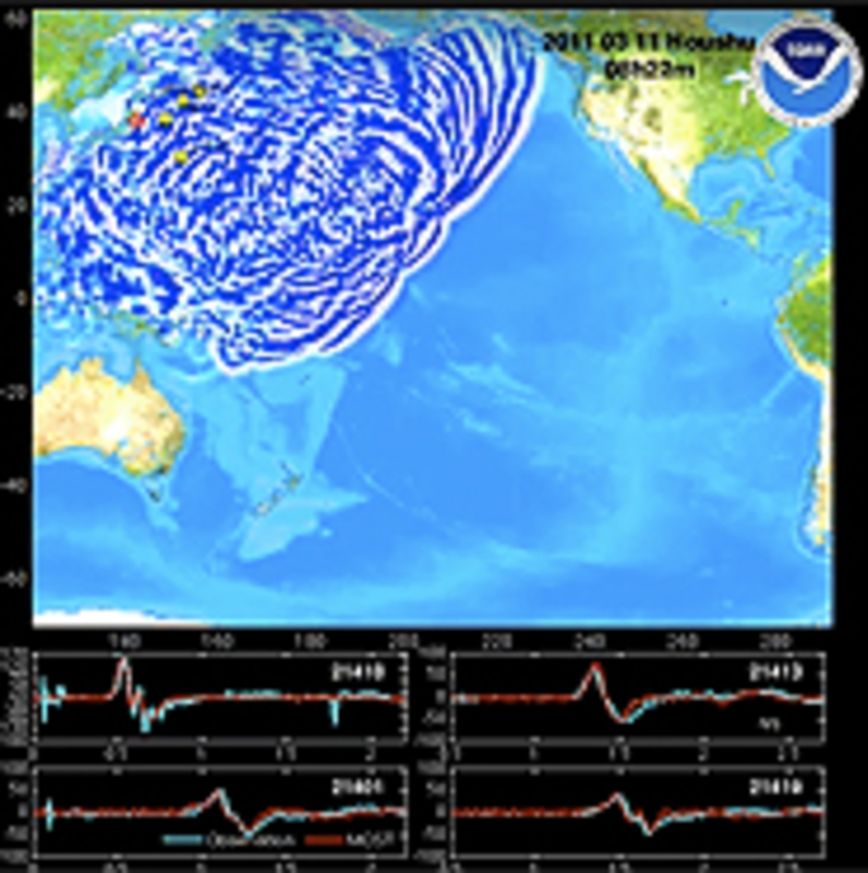
A typical magnitude 8 might be on the order of a hundred miles long and 50 to 60 miles in width. This rupture was about 350 miles long and 150 to 175 miles in width. That is an enormous area to be deformed and a phenomenal volume of ocean of seawater that is displaced, and the largest surges fall right back on to the nearby coastline and the remaining surges head out across the Pacfic. It’s not that we haven’t had earthquakes that size before. We had an 8.8 in northern Chile only a little over a year ago and of course the great Indian Ocean tsunami in 2004 caused by the Andaman-Sumatra earthquake — that was a magnitude around 9.2. This earthquake is still not as big as the largest earthquake that we’ve ever recorded with modern instruments, a 9.5, and that occurred in 1960 when a very similar kind of fault ruptured much of the south-central Chilean subduction zone.
These great earthquakes do an incredible modification of the Earth’s surface. In the recent Japan earthquake, the plate that is subducting is the Pacific plate and it’s going under the North American plate. Most of the time those two are stuck together, but the Pacific plate is continuing to subduct all the time. It’s moving at about the rate that your fingernails grow. So that subducting plate is being basically pulled down by gravity. And as that plate gets pulled underneath it literally squeezes or compresses the plate on top just like a giant spring. That may keep going on for hundreds or even a thousand years. When the strength of that bond between the two plates is finally too great, we get this mega-thrust earthquake, this rupture that goes along the fault system. The overriding plate suddenly springs back. And it probably wasn’t just one single rupture. There were probably a number of secondary faults that may have also ruptured near that edge.
e360: Could you make an analogy that the plate kind of springs up, almost like a floorboard that was under pressure that pops up all of a sudden?
Dengler: Yes. It’s like a spring that’s been loaded. So imagine this board has been pulled down, pulled down, pulled down and then suddenly it’s released, and it’s going to pop up very quickly.
e360: Right. Let me ask you about earlier earthquakes and tsunamis in Japan.
Dengler: The worst was in 1923 and that was the great Tokyo earthquake that killed something like 140,000 people.
e360: That was a smaller magnitude?
Dengler: It was smaller in magnitude, but that earthquake was centered very close to Tokyo and it triggered an enormous fire and the fire probably contributed to more deaths than the earthquake. The earthquake occurred at a time when people were preparing dinner and at that time they used these open fire braziers. Most of the homes were wood construction and it very, very quickly became an inferno. So that was without question the worst earthquake disaster. It did produce a tsunami, but not a great tsunami. Each one of these events has their distinctive set of parameters, and in one it may be ground-shaking damage, and in another it may be fire, and another it may be an enormous landslide or it could be a tsunami, or a combination of those things.
Japan has had numerous earthquakes as large as magnitude 8.5, and that may have been kind of their planning event. But it really points out the problem of dealing only with the historic record. Japan has records that go back a thousand years or longer — a much longer record than we have in the United States, where we really only have written records on the West Coast going back about 150 years, and we’ve only had actual seismic instruments going back about a hundred years.
So in order to get a sense of the long term hazard, you need to go into what we call paleoseismology, paleoseismic techniques, which use the geologic record of past events to interpret the full scale of what you might be dealing with. And that’s certainly how we know the most about the hazard in Cascadia [U.S. Pacfici Northwest]. It comes primarily from the paleotsunami and paleoseismic studies that have been done in Northern
| There is evidence that what has happened in the last thousand years is not necessarily the worst-case event.” |
California, Oregon, Washington, and British Columbia. Some of those studies have certainly been done in Japan as well, and several years ago Japanese researchers published a paper that suggested the past tsunamis were much, much larger than any that had been observed in historic times. The sand sheets particularly in some areas of Hokkaido and northern Honshu extended much, much further inland than the historic record suggested. And there certainly has been some discussion that earthquakes as large as low- to mid- magnitude 9 were possible in that area. I don’t know if that information had been incorporated into any of the planning for this event. But there was certainly some evidence that suggested that what had happened in the last thousand or so years was not necessarily the worst-case event.
e360: The paleo record shows sand sheets that come in from the sea and spread over the land?
Dengler: Exactly. And the problem with that evidence is that, first of all, it’s ephemeral — it will tend to be eroded. If you imagine the Pacific Northwest, we have a lot of rains. We have a lot of floods. So preserving it is difficult. And interpreting it can be difficult as well, and so there are a number of people who have become paleotsunami experts and by analyzing not only the sand, but looking at the micro fossils in it, you can look at the diatoms and forams and interpret them as coming from the ocean.
e360: In the historical record, you’ve got the Meiji-Sanriku tsunami and earthquake of 1896?
Dengler: Yes. So this was in the time of the Meiji emperors, so that’s how we often describe it.
e360: It originated in roughly the same area as the recent tsunami?
 It took nearly 24 hours for tsunami waves created by the Chilean earthquake of 1960 to reach the Japanese coast. |
Dengler: Roughly the same area. That earthquake was quite different from this earthquake. It was what we call a tsunami earthquake. We use the term tsunami earthquake when the tsunami is much bigger than you would expect for either the size of the earthquake or the strength of the ground shaking. So in that particular case people didn’t feel the earthquake very strongly. It was weak shaking that lasted for a long time, but it didn’t knock things down. You had this earthquake, which didn’t feel very strong, and people didn’t tend to pay a lot of attention to it and unfortunately the tsunami was very large. In Japan there is an oral history that says that if you feel the earthquake you go to high ground. And when you have these tsunami earthquakes you just don’t tend to be as alarmed by the shaking. So one of the things that I always tell people is pay attention to how long the shaking lasts. It may not feel all that strong, but if you count ground shaking that lasts 30 seconds or longer, then that’s your warning and you really do need to evacuate.
e360: And in the 1896 tsunami, virtually all the deaths were from the tsunami?
Dengler: There was no damage at all from the earthquake. It was entirely the tsunami.
e360: Were the same coastal regions that were hit two weeks ago also hit in the 1896 tsunami?
Dengler: There was a lot of overlap. And the 869 Tohoku tsunami affected many of the same areas, as well.
e360: And was there an estimate of deaths back then?
Dengler: The estimate was over 1,000 deaths in 869 and that flooded a castle in Sendai, so really the same areas flooded… One of the things that is going to be emerging from this recent tsunami is the focus has been on the failures, because clearly when you have 10,000 or maybe even 20,000 deaths, it’s a catastrophe. But there were hundreds of thousands of people exposed and there are certainly successes as well. And we just haven’t been hearing about them yet.
e360: Successes in terms of warnings…
Dengler: Of people successfully evacuating and surviving. I think we are going to find out that many more people lived than died that were in the tsunami area, and that’s quite different than what happened in the 2004 Indian Ocean tsunami, where virtually everybody that was in the inundation zone died because they were unaware of the natural warning signs of a tsunami, and at places further away from the source, in Thailand and in Sri Lanka, there was no kind of warning system. So I’m sure that there will be many successes that will come out of this and that’s important to remember.
e360: In North America, is there a similar plate structure off of Cascadia and Northern California so that you could have an earthquake and tsunami of similar intensity in the Pacific Northwest?
Dengler: Yes. And in fact we know perhaps the most about the potential for such an earthquake and tsunami from the written records in Japan. On January 26, 1700 we had a very similar rupture in the Pacific Northwest. It probably extended from south of Eureka, in northern California, up into about the middle of Vancouver Island, Canada. And given that length and given what we know about the Cascadia subduction zone, it was probably about a magnitude 9. The earthquake rupture caused the same kind of phenomenon, with permanent deformation of the
| At the top of the list of things we need to work on is public awareness and public education.” |
coastlines, killing many forests of western red cedar, redwood trees, pines, and spruce. The western red cedar, though, is a particularly important tree because it doesn’t rot very quickly and there are still today stands of ghost forests, these western red cedar that died in that event. Because there are still living trees from the same grove that were a little higher up, it is possible using the science of dentrochronology [reading tree rings] to actually create the time history of those trees and when they died. If you’re really careful and work on the roots, you can actually figure out the death date of those trees. That was done in southern Washington State and they found seven trees they could actually get a good death date on. And of those seven trees, six of them put on 1699 growth rings and did not put on 1700 growth rings. And as I said from the Japan written records, the tsunami came on January 26, 1700.
In Japan in 1700, we’re in the height of the Togakawa Shogunate, a very stable period in Japan, which means the bureaucrats are writing down records. Lots of taxes were being paid to the Shogun, and the taxes are basically paid as rice, and the rice gets stored in warehouses close to rivers and close to ports. And so we’ve got these reports of the tsunami coming in and it wiped out so many bags of rice and it came up this high. We can actually get a pretty good estimate of how high the water came in 1700 and when it arrived. And, from that, you can actually do numerical modeling that also says you basically need a magnitude 9 earthquake in order to produce that size of a tsunami. Both sides of the ocean, we give and take to each other.
e360: And how far off the Cascadia Coast was this fault line from 1700?
Dengler: It was the edge or the Cascadia subduction zone, which is defined by the continental shelf. So you can see that it is very close to the northern California coast. It is only about 50 miles off the coast. By the time you get off the Washington coast, it’s over a hundred miles off the coast. So we would expect when that fault system ruptures, the first surges are going to arrive on the northern California coast in as little as 10 minutes after the earthquake rupture. By the time you get up to the Washington coast you are probably dealing with closer to 20 minutes, unless the ground shaking also triggers a submarine landslide much closer to the coast, in which case a secondary tsunami could arrive even more quickly.
e360: So if you had a similar event to the 1700 tsunami off of Eureka and the Cascadia Coast, you could be looking at death and destruction on a scale of what just occurred in Japan?
Dengler: There are of course lots of uncertainties and the actual character of the rupture and the frequency of ground shaking is a huge unknown. We don’t have the exposure in terms of population [right on the coast] that that part of Japan had. We don’t have a Sendai that has hundreds of thousands of people potentially exposed. We do have lots of small communities that on a lovely summer day can have tens of thousands of people on the beach. So, you know, 4th of July, if it’s not foggy on the Oregon and Washington coast, you can have certainly many people exposed. And it’s something that we’re actively working on. We have tsunami hazard maps. We have hazard zone signs. Most of our coast is actually at fairly high elevations so it turns out most of the places where people live are actually not at great risk.
e360: What about San Francisco?
Dengler: Well San Francisco is probably not at great risk of a tsunami. Hawaii is going to get more damage from [a Cascadia] tsunami than San Francisco will. Alaska will get damage from our tsunami and Japan will get damage from our tsunami. So this event certainly has the capacity to cause significant problems throughout the Pacific basin. San Francisco is going to escape the worst of it because it’s on the good end of the rupture.
e360: How well would you say the U.S. and Canada are prepared for a big tsunami that would strike Hawaii and the West Coast?
Dengler: I’m sure there are going to be many hearings in the coming months that will be addressing this topic. Actually a number of [Congressional] hearings were held back in 1993 and 1994 after we had a 7.2 earthquake here on the North Coast on that same subduction zone fault system, but it was just the southern-most corner of it. But that earthquake was enough to really get people’s attention. As a result, the U.S. launched the National Tsunami Hazard Mitigation Program in 1996, funded solely by earmarks, until the 2004 Indian Ocean tsunami, when suddenly the funding jumped way up. The National Academy of Sciences and the National Research Council just finished a two-year study of the U.S. tsunami program that looked very, very carefully at all aspects of U.S. tsunami preparedness. It has certainly improved significantly from where it was a decade ago, but there are a number of areas that we need to continue to work on.
|
MORE FROM YALE e360
The world’s worst nuclear reactor mishap in 25 years was caused by a massive natural calamity but compounded by what appear to be surprising mistakes by Japanese engineers. The result has been a fast-moving disaster that has left officials careening from one emergency to the next. |

I would say top on that list is public awareness and public education. There is no question when you are dealing in the near-source region of a great earthquake everybody needs to understand that they can’t wait for an official warning. They can’t get in their car and drive. They need to be able to self-evacuate immediately. And we have a number of areas where there’s no high ground. An example is the Long Beach Peninsula in Washington State, where you have this big long sand pit with no high ground. We need to really be looking at issues of creating high ground, of vertical evacuation. It is going to be very interesting to see how Japanese vertical evacuation sites fared. I’ve heard some stories of the water being higher and completely overtopping some of them. But it’s too early right now to know. But if a Cascadia earthquake and tsunami were to happen this afternoon, we would certainly have major damage and we would lose lives due to the tsunami. I would like to think we would lose far fewer today than if it happened 20 years ago. So this is a work in progress, and we have a lot still to do.
e360: I think what’s been so stunning to everyone was that here’s this incredibly developed country [Japan] totally aware of the dangers it faces, and it still got absolutely creamed. It’s shocking.
Dengler: Absolutely. It’s extremely humbling and I’m not going to predict what Mother Nature will do next. But let’s just say she holds all the cards and is the last at bat.
Japan Tsunami Reconnaissance – Wrap Up and Lessons for the Future
Lori Dengler, May 25, 2011
This will be my last post for this reconnaissance trip. I had a smooth return trip – all flights on time! On my last day in Tokyo I met with Professor Tsuji of the University of Tokyo. Tsuji-sensei is well-known in tsunami science – having participated in or lead post-tsunami field investigations all over the world. His keen eye, breadth of background, and infectious humor have helped to create the International Tsunami Survey Team (ITST) format that we use today. He is also known for having found the highest inundation in the 1993 Okushiri tsunami (over 90 feet), and the second highest point in the current tsunami (over 120 feet). He is a very busy man, the phone constantly ringing with inquiries from the media, government officials, and other scientists. I was lucky to have an hour appointment. He’s seen much more of the inundation area than I have. I was particularly interested in the story of the town of Taro in Iwate Prefecture. Taro was famous for the Japanese “Great Wall of China “ a towering 33-foot edifice that was completed in 1958 to protect the town from tsunamis. When new development began outside the limits of the older walls, a new was extended in the 1990s to cover this area also. Unfortunately, the construction company which built the new wall failed to put in steel or other reinforcement to hold sections of the wall together and the tsunami toppled them as easily as child’s blocks. The tsunami was high enough to overtop the old walls as well, but they didn’t topple and the level of damage in the older area was a little less. The standing walls did reduce the amount of flooding and gave residents an extra few minutes to get to higher ground. More on Taro here [YouTube].
I asked him about how Japan should be approaching tsunami hazard mitigation issues in the future. He suggested a two-tier approach. Tsunamis are much more frequent in Japan than on the West Coast of the United States. Major tsunamis occurred in 1896, 1933 and 1960. Sea walls and engineered tsunami abatement structures should still be the primary line of defense for these relatively common tsunamis. But there needs to be a second tier – a life safety plan to protect people from much larger tsunamis such as the March 11 event. This is what needs to worked on and applied to other tsunami prone areas as well as the NE coast of Honshu.
I’m still sorting through my notes and photographs to summarize our findings from the trip. I took more than 1200 photos and Megumi Sugimoto, a postdoctoral scholar at Tokyo University, has a similar number. We conducted more than 30 detailed interviews. I am also pouring through the reports from other scientific teams and the flood of government and other reports that have been released. Here are my preliminary thoughts on the themes that are emerging. My disclaimer is that “preliminary” is the operative word here. Additional information may change some of these findings.
The most important lesson is that underestimating the hazard has tragic consequences.
Japan spends more of their GDP on earthquake and tsunami hazard mitigation than any other country in the world. This includes more instruments, more tsunami scientists and engineers, more numerical modeling, and more engineering works. These mitigation efforts were built on an assessment of the size of the likely maximum earthquake and maximum tsunami that turned out to be wrong. The majority of sea walls in the affected area (like those in Taro) built to restrain the tsunami and many of the designated vertical evacuation places were overtopped or failed in the event. Because it was expected that the mitigation efforts would be effective, there was no catastrophic response plan in place. This affected the ability to effectively respond, to coordinate both national and international offers of assistance, and prolonged the amount of time some people were on their own in isolated evacuation places.
There had been a few studies by geologists that suggested a much greater hazard than had been adopted in planning efforts and it is easy now to point back at those studies and say they should have been used. Hazard assessment is a difficult process, the historic record (even in Japan) is short and interpreting paleoseismic data is not always straightforward. Megathrust earthquakes (earthquakes with magnitudes of 8.5 and greater) are particularly tricky because they are so rare. Sixteen magnitude 8.5 or larger earthquakes have been recorded on seismographs (post 1900), and only five of these were magnitude 9 or larger. Both 9+ earthquakes that have occurred since modern broadband instruments have been in existence have changed the conventional wisdom. The 2004 Andaman Sumatra earthquake changed our ideas about the relationship among earthquake size, age of crustal material, and convergence rate, and the Japan earthquake is challenging the accepted scientific ideas about the relationship among magnitude, fault area, and slip.
I have been privileged to work with and learn from many of Japan’s earthquake/tsunami professionals for years and as a group they are an extremely hard working and conscientious group, and this earthquake showed that much of their effort was successful. On first look, it appears that the built environment performed very well even when subjected to some of the strongest ground shaking levels ever recorded. The early warning system that analyzes an earthquake during the initial seconds of the rupture appears to have worked in shutting down trains and other facilities before the strongest shaking. While power went out at 2:46 PM when the earthquake struck, sirens, cell phones and radios continued to work in all of the areas we visited. In Chile, after the February 2010 M 8.8 earthquake, only one radio station continued to work in the Bio Bio region and cell phone coverage was down. In recent much smaller California earthquakes (2008 M 5.5 Chino Hills, 2010 M 7.2 Baja) both cell and landline telephone communications were jammed by overuse. But all of the successes in reducing earthquake impacts are overwhelmed by the enormity of the tsunami losses.
What I am taking away from Japan is the importance of allowing for uncertainty in hazard estimation and making sure we are conservative when it comes to life-safety decisions. We’ll be taking a long second look at what we have been doing in California – and I know that other folks working in the Cascadia region will be doing the same.
Here’s a quick take on other lessons (in no priority order)
• People not aware of risk. Few of the people we talked to thought they were at risk where they lived or worked. We don’t know the reasons for this – whether they believed the sea walls would protect them, or education efforts weren’t effective, or there were other reasons. I hope other groups study this issue in more detail.
• Vulnerability was a function of the unique geography of a location and the characteristics of the tsunami (height, flow velocities, duration, and arrival time). The situation on the broad coastal plain near Sendai was very different than the population centers like Minami Sanriku and Kesennuma that were built on alluvial flood planes and valleys near the mouths of large rivers. At East Matsushima, the situation was complicated by exposure from the ocean, a large river, a canal, and Matsushima Bay.
• Elderly appear to have been more vulnerable.
• Evacuation issues
People relied on cars
Planning centered on vertical evacuation in designated structures, rather than getting to high ground outside of the hazard area.
The earthquake often triggered behavior – but not to evacuate to a safe area. A number of people who were in safe areas, drove back to into hazardous areas after feeling the earthquake. Most often the reason was to check on/rescue loved ones at home, but in some cases it was to retrieve property.
• Response/Recovery
Evacuation places were unprepared to hold people for days in winter conditions
Enormous shelter needs and inadequate shelter facilities – frustration of people in shelters with lack of privacy, bathing facilities, and lack of information about what is happening in their home towns.
Enormous temporary housing needs
Long duration loss of utilities and services in the affected area requiring resources – such as an army of traffic control officers at major intersections now without traffic signals
Coordinating volunteers
Relentless reminders of the event Aftershocks News/media coverage – daily revised body/missing counts, radiation levels
Reconstruction debates – how to rebuild and mitigate hazards from future tsunamis
• Loss of confidence in technical community
• The patience and perseverance and kindness of the people affected – lack of looting, cooperation, and general willingness to talk to us!
These notes are an informal summary of the ten day visit to earthquake/tsunami regions of Japan beginning April 30,2011.
The Lessons of the Great East Japan Earthquake and Tsunami for the World
Lori Dengler interviewed by Mark Selden
•Let’s begin by examining the nature of the 3.11 event and its impact.
According to the report compiled by SeedsAsia based on Japanese government documents and media reports through April, there were more than 14,500 dead and 11,000 missing. There has been little change in these numbers since. Approximately 92% of the deaths that resulted from the 3.11 earthquake/tsunami/nuclear power disaster were the result of the tsunami. Of these, 94% drowned and most of the remainder were killed by crushing or fire. This refers only to those whose bodies were recovered. The figure for drowning deaths rises to 97% when the missing are added to the tsunami column.
By contrast, the earthquake alone probably took between 600 and 700 lives. Traveling widely through the affected region two months later, I was impressed by how little earthquake damage was visible. From the perspective of the earthquake alone, this would appear to be a remarkable success . . . comparable to the results that were achieved in 2010 in Chile. Yet there were remarkable differences in the outcomes in different communities.
In the case of Tohoku-oki, it is important to recognize that it was a one-two punch – first the earthquake and then the tsunami. We need to think of the two as a single package, but with different routes to reduce the impacts. You prepare for a tsunami differently from an earthquake. In a tsunami, human behavior in the course of the event is of ultimate importance. The decisions that individuals make during the earthquake can result in life or death. This is often less true in the case of an earthquake where the quality of the built environment is usually the most important factor. Being aware of what areas are at risk, how to get to high ground , and what is the trigger to evacuate makes all the difference in the case of a tsunami.
•What are the major lessons of the 3.11 disaster for future preparedness and rebuilding?
It is always difficult to prepare for and manage rare catastrophic events. Japan is one of the most seismically and tsunami-prone nations on earth and has a much longer written historic record than most places. In the last 120 years, three great tsunamis have struck the North Eastern coast of Honshu – the 1896 Meiji tsunami, the 1933 Showa tsunami and the 1960 tsunami that came from Chile. But none of these approached the size of the March 11 event. You have to go back to the geologic record to find a tsunami that may have been comparable – more than 1000 years ago, in 869 CE during the reign of emperor Jogan. And paleo evidence suggests that comparable scale events may have occurred at intervals of approximately 1,000 years. So the Japan earthquake will ignite a debate about the appropriate levels of preparedness for events that occur on different time scales.
Any kind of hazard mitigation has to be done in a cultural context. Different societies have different types and levels of capacity –technological, educational and economic. Haiti is an example of a society that had little capacity to respond effectively at the time of the 2010 earthquake: there was no planning to reduce impacts beforehand,,no state and human resources to cope with the aftermath, and limited possibilities as to how to reduce the future risk. Japan has substantial capacity to respond to emergencies, and it has expended more of its GDP on earthquake and tsunami preparedness than any country on earth. Japan has multiple avenues to address mitigation including engineering, land use and regulatory options, and education/outreach. Learning from how other developed societies like Japan makes these difficult decisions can help other countries respond to disaster. And if you have the capacity, you take what you can and apply it drawing on your own culture.
Japan’s first line of defense for tsunamis has focused on technology and engineering. Japan has early warning systems that can detect initial indicators and within 30 seconds can act to shut down trains and power plants. It appears that these systems were fairly effective in the immediate response. But initially this same system underestimated the size of the earthquake and the ensuing tsunami.
The first estimate was for a 7.9 quake and a 3 meter tsunami. All earthquakes take time to rupture. The twenty seconds of seismic data the Japanese early warning system uses to make the preliminary analysis does ok to capture the relative size of an earthquake in the magnitude 7 range. But it is incapable of seeing the minutes of data that a magnitude 9 earthquake rupture produces. At this point, it is not clear how significant this initial underestimate was in terms of guiding people’s decision to evacuate or not. The small sample of people we talked to in Japan hadn’t heard this first estimate. They generally first heard the warnings 5-10 minutes later, by which time the level of risk had been raised to a higher level.
There’s already much discussion in the Japanese media about how to reduce tsunami vulnerability when communities are rebuilt. The discussion includes rebuilding of sea walls, and some have suggested building them much bigger. Japan is more accepting of an engineered coastal environment than many other parts of the world. There’s a cultural expectation for sea walls and I expect that at least some, and perhaps many of the sea walls and other abatement structures will be rebuilt. But will they think about building as before to protect for a more common 100-year event, or will new thinking prevail requiring preparedness for a 1000 year event? I don’t think 20 meter sea walls are economically or structurally viable and I expect to hear other options discussed in order to address life-safety issues for rare but catastrophic events such as what happened on March 11.
But many other factors need to be considered with respect to mitigation. It is worth reflecting on the different situations, and the different approaches taken by different Japanese communities.
Consider, for example, the Wakabayashi area of Sendai, an agricultural area with not a lot of business and few homes close to the coast. Compare it with Yuriage nearby with a dense population concentration near the coast. In some communities in hilly Iwate Prefecture, housing is located in the hills and the lowland is devoted to agriculture. This natural land use evolution reduced the exposure of residents to the tsunami. Such communities can be expected to minimize casualties in the event of a severe event such as a large tsunami.
Applying land use planning solutions in a country like Japan where every inch of arable land is currently used is difficult. But because so many communities were essentially erased by the tsunami, this disaster also creates an opportunity: it becomes possible to rethink from scratch how to rebuild better and protect lives.
To me, one of the most interesting aspects of what happened in Japan, and a critical lesson for the rest of us, is what triggered people to evacuate and how they made their evacuation decisions. In most areas, there was actually plenty of time for the majority of the exposed population to get out of the hazard area, if they had immediately responded to the natural warning of the ground shaking and gone to an area outside of the inundation zone. In the Sendai plain, there was an hour from the time of the quake to the devastating surges of the tsunami. Further north, the time between the earthquake and the tsunami was typically 20 to 30 minutes. So it is important to understand why some people did not escape.
NHK conducted a survey of survivors and found that over half did not think that they were at risk of a tsunami. We don’t know for sure right now why they did not believe themselves at risk – perhaps they thought that the sea walls would protect them or the educational message did not get through. I am hoping that other tsunami reconnaissance teams will be able to answer this question.
But what we do know is that for many of the people we interviewed, the earthquake shaking was a trigger – but for the wrong behavior. People who were outside of the tsunami hazard zone became concerned about relatives or belongings on feeling the earthquake. They acted on their concern by driving back into the hazard zone. We only talked to the lucky ones who managed to avoid the surges and still survive.
One of the most difficult nuts to crack is how people perceive risk. We can have a perfect technological detection and notification system but, if no one responds, all the mitigation efforts are for nought. We are genetically programmed to deny risk . . . otherwise we’d be permanently in terror, whether driving a car or flying in an airplane. So we’re slow to recognize when we’re really at risk.
Amanda Ripley wrote an important book, The Unthinkable: Who Survives When Disaster Strikes–and Why, on how people respond to events outside their experience.
Ripley gives many examples of people responding inappropriately in the first moments after an unexpected event occurs. She also talks about several notable successes including Langi Village on Simeulue Island off the Aceh coast of Sumatra. In 2005, I participated in a reconnaissance team that visited Indonesia. Along the hard-hit Aceh coast, we visited places that had a 2-5% survival rate from the 2004 tsunami that arrived about 20 minutes after the ground shaking. These towns and cities had been obliterated and we saw almost no one during our fieldwork. Langi village was the populated area closest to the epicenter of the 2004 earthquake. The earthquake shaking was very strong and only eight minutes after the earthquake began, surges 10 to 15 meters destroyed every structure in the town. I fully expected the death toll to be as bad as in Aceh. But I was surprised – in Langi not a single man, woman, or child died. Even the elderly survived. Simeulue Islanders have an oral tradition that preserved memories of a tsunami that had occurred 5 generations previously. The local people had a word, smong, which means a really strong earthquake that changes the land and lasts for days. When it occurs, everyone knows to go to a place 90 feet above sea level. Our fieldwork was pleasantly hampered by many of the villagers following us wherever we went.
Simeulue experiences fairly frequent large earthquakes. Only two years before the 2004 event, a strong earthquake had triggered everyone to evacuate but no tsunami followed. Why did they continue to evacuate after each earthquake when no tsunami followed? They said that every event was an opportunity to practice their evacuation skills. Such examples elevate the importance of human behavior in explaining outcomes of disaster events: and this applies equally to hurricanes, tornadoes, flash floods. You have only moments to make decisions that determine whether you survive.
We can learn much from non-technological societies about human behavior and other methods that work. Some things are transferable, while others are culturally specific. Japan will now wrestle with the questions of what can be learned from their own recent experiences and from the experiences of others.
But solutions will be constrained by economic hard times. It is probably no longer possible to have a purely engineering solution. If they seek to protect against a 1,000 year event, the size of sea walls that will assure protection is probably prohibitively costly. So it becomes necessary to consider the combination of engineering and other solutions.
•You mentioned the fact that major earthquake/tsunamis have been 1,000 year events. There are those who believe that the rates of disasters has been increasing in recent decades, perhaps as a result of global warming, perhaps as a result of the remaking of the landscape by human beings.
Is the rate of catastrophes increasing? Big reinsurers like Munich Re publish summaries of disasters throughout the world. Their figures cover the last fifty years, cataloging not only disasters but the insurance payments that followed.
They were the first major industry to target the possible economic costs of climate change. Reinsurers insure insurance companies that issue policies for disasters such as storm events and earthquakes so it is in their economic interest to understand trends that affect their bottom line. Their data show that the number and cost of disasters has increased over the last century. Part of the reason is that the world’s population has risen, and the value of property has also risen. So even in the absence of changes in physical parameters, we’d be dealing with greater losses.
Data suggest that climate-related events have increased over the past century. Of course, there’s a debate. But with more energy in the atmosphere, it follows that you’ll get more atmospheric events.
Trends for non-weather events such as earthquakes are not so clear. There has been discussion in the media about the increase in the size and number of great earthquakes in the past decade. It has been a seismically exciting period – with a magnitude 9.2 (Indonesia), a 9.0 (Japan) and an 8.8 (Chile) after forty years of no earthquake as large as 8.5 occurring. But we’ve got a very narrow perspective on earthquake periodicity. We only have seismographs since 1900, and good global instrument coverage only after 1960 when the atmospheric nuclear test ban treaty drove nuclear testing underground. So there was a compelling need for seismographs to assess underground explosions. It wasn’t until the 80s and 90s that modern broadband instruments became available. Until then, you couldn’t really capture the total size of an event. It was like listening to a symphony in which you could only hear the oboes and cellos. Now we have much more high-quality records.
But even with the less-than-perfect distribution of seismographs over the past century, we can make a pretty good estimate of the total energy release in earthquakes over this period. When it comes to energy, little earthquakes don’t count and we probably haven’t missed any magnitude 8 or larger earthquakes since 1900. And although the last decade has been seismically energetic, it doesn’t win the prize for the past century. The winning decade is the years 1956-1964, when a 9, 9.2 and 9.5 occurred. What this suggests is that earthquakes are clumpy. But there is no indication of long-term changes in frequency or intensity.
Mark Selden is an Asia-Pacific Journal Coordinator.
Recommended citation: Lori Dengler and Gregory Smits, The Past Matters: Lessons From History and From Japan’s March 11 Earthquake and Tsunami, The Asia-Pacific Journal, Volume 9, Issue 23, No. 1, June 6, 2011
|
Articles on Related Subjects
• Matthew Penney and Mark Selden, What Price the Fukushima Meltdown? Comparing Chernobyl and Fukushima. • Hirose Takashi and C. Douglas Lummis, The Nuclear Disaster That Could Destroy Japan – On the danger of a killer earthquake in the Japanese Archipelago. • Gregory Smits, Danger in the Lowground: Historical Context for the March 11, 2011 Tohoku Earthquake and Tsunami. • Christine Marran, Contamination: From Minamata to Fukushima. • Yuki Tanaka and Peter Kuznick, Japan, the Atomic Bomb, and the “Peaceful Uses of Nuclear Power.” • Peter Karamoskos, Fukushima Burning: Anatomy of a Nuclear Disaster. |
Notes
1 Takeshi Sekiya, “Investigate all available data,” Nature, vol. 473 (12 May 2011), pp. 146-147.
2 Research by Matsumoto Hideaki. See “Sendai heino, Yayoi jidai ni mo kyodai tsunami ni osowareteita,” Yomiuri Online, May 16, 2011, 8:22am.
3 SEEDSAsia, “The Great Eastern Japan Earthquake: In depth damage report by affected cities and children: In Depth Damage Report by Affected Cities and Children.” April 13, 2011. See also “Situation Report 16,” April 30, 2011.
4 Herry Yogaswar and Eko Yulianto, “Local Knowledge of Tsunami among the Simeulue Community, Nangroe Aceh Darusallam,” in Assessing and Recognizing Preparedness in Natural Disasters in Indonesia; Brian G. McAdoo, Lori Dengler, M.EERI, Gegar Prasetya, and Vasily Titov, “Smong: How an Oral History Saved Thousands on Indonesia’s Simeulue Island during the December 2004 and March 2005 Tsunamis,” Earthquake Spectra, Volume 22, No. S3, pages S661–S669, June 2006.