
Abstract: Watanave Hidenori and his team at the University of Tokyo use social media, satellite images and other digital resources to research and map wars and natural disasters, partly as a way of rebooting and preserving their memory. In addition to the 1923 quake, the team has produced digital archives of the Hiroshima and Nagasaki nuclear bombings, and the 2011 Tohoku (Great East Japan) tsunami, and they currently track war damage in Ukraine, following Russia’s invasion in 2022. Questions by Tristan Grunow, Laura Hein, and David McNeill. Questions were posed in English, to which Watanave responded in Japanese. Answers have been translated from Japanese, and can be found after the English interview.
Keywords: The Great Kanto earthquake, digital mapping, Ukraine War
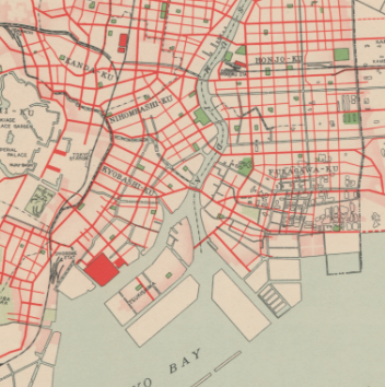
Your most recent digital mapping project is The Tokyo 1923-2023: 100 Years digital mapping project, which introduces some incredible visuals of the aftermath of the 1923 Great Kanto Earthquake and damage throughout the Tokyo and larger Kanto areas. Can you tell us more about the origins and goals of the project?
We collaborated with the National Museum of Nature and Science as editorial supervisors of the “History of the Great Kanto Earthquake: Science and Technology for the Future” exhibition, which commemorates the 100th anniversary of the earthquake. The idea was to create content using the valuable materials in the museum’s collection, so we applied our digital archive methods to create the aerial images. The objective is to provide visitors and Internet users with an opportunity to view the disaster of 100 years ago as a continuation of our own time. In addition to mapping aerial photographs, we are also working on colorizing the photographs of the time.
Browsing the images, we were struck not only by the tremendous destruction from the fires caused by the earthquake, but also by the very nature of the photographs themselves, apparently taken from a biplane investigating the damage from the air. Where did these images come from, when were they taken, and what was their original intended purpose?
They were taken by the Imperial Japanese Army and Navy. The photographs we used were all taken from the day after the disaster over a couple of days (exhibition captions were created by Tomoko Murotani of the National Museum of Nature and Science). According to the earliest records, the initial purpose of the photos was to confirm the safety of the royal family, etc. Later, the photos were probably taken to assess the situation in the affected areas in various parts of Tokyo and Kanagawa Prefecture.
Naturally, we would expect to see images of damaged areas taken to assess the extent of destruction, but there were also other images depicting significant Tokyo urban structures – such as Tokyo Imperial University, the Zojoji Temple, the Ryogoku Kokugikan, etc. – that seemed to have escaped extensive damage. Just based on which parts of the city were photographed, we almost get a sense of which areas were deemed the most important at the time. Do you have any idea why certain areas of the city were photographed while others were not?
Aside from places like Honjo Ward, which was almost completely destroyed, the Koishikawa Arsenal, Imperial University, and the Imperial Palace area were also “key locations,” so it is assumed that they were taken at the discretion of the military. There were also military facilities in the coastal area, such as the Nagareyama Arsenal (in Chiba Prefecture – used to store and supply military provisions for the Japanese Army).
There are many contemporary depictions of the Great Kanto Earthquake and its aftermath – including postcards, photos, woodblock prints, and maps (see Gennifer Weisenfeld’s Imaging Kantō digital archive and article in this special issue for more). Why did you choose this specific set of photographs to include, and were there other available images that didn’t make it into the Tokyo 100 Years digital mapping project? How did you select which photos to include?
Only the aerial photographs provided by the National Museum of Nature and Science in which the location could be identified are shown here. This also overlaps with the answer to the next question. It is difficult to identify the location of the photo unless it shows a wide area. We continue trying to identify locations. In addition, since it is a struggle to map photos taken from the ground, we have colorized about 25 photos from the National Museum of Nature and Science and the Tokyo Metropolitan Memorial & Reconstruction Museum.
In addition to the visual record of the tremendous destruction caused by the earthquake, another really striking aspect of the Tokyo 100 Years digital mapping project was the juxtaposition between Tokyo today and the damaged areas 100 Years ago. Not only can we see just how different Tokyo and the Kantō Area as a whole looked in 1923 compared to today, but we also get a very real, much more visceral idea of the scope of the damage when comparing it to places today we are so familiar with. How do you envision this project helping the general public, students, and scholars better understand and research past events like the Great Kanto Earthquake?
First, you will be surprised to see the many inherited landforms in Tokyo 100 years later. There is considerable overlap in coastlines, roads, and rivers that are now elevated (which is why we were able to superimpose them). Although the topography has been inherited, we can also see that the city has become much taller and more built up over the 100 years. There are few people still around to pass on the memories of 100 years ago. These contents convey the memories of Tokyo in the past on behalf of the people who lived in those days.
In addition, as the viewer moves back and forth between Tokyo today and a century ago, the sense is sure to arise that this is not the past, but the Tokyo of the future. In fact, Tokyo, which had recovered from the Great Kanto Earthquake, was burned to the ground again just 22 years later in 1945, during the Tokyo Air Raid (of March 1945). Tokyo has a history of being repeatedly hit by large fires, even during the Edo period. Through these contents, we hope you will realize that earthquakes and fires are not only a record of the past, but also something that could happen again.
Many of your lab’s previous digital mapping projects have included oral histories and recollections, focusing on two types of major events, war – such the Hiroshima Archive, Nagasaki Archive, Pearl Harbor archive, Okinawa Archive, along with the more recent war in Ukraine – and natural disasters, such as the Tohoku Triple Disaster, the earthquake in Turkey/Syria, and now the 1923 Great Kanto Earthquake. In this video about the earthquakes in Japan and Turkey/Syria, in particular, you lament that once media attention moved on large areas of the region received no coverage. Is this where your mapping projects can help prevent our memories of disaster and war from fading over time as each new event “overwrites our memories”? Some might say this is an inevitable part of the recovery process, or is that, too, selective and political?
It is a remarkable human trait to be able to forget the tragic memories of the past and carve out new lives. However, there are some things that are better for our species not to forget. For example, what happens when a catastrophe strikes? How do we save our lives? What actions should each of us take to prevent the spread of a disaster? These are some of the points that should be considered. Also, war is man-made. It is important to remember what the consequences are. We believe that a digital archive will be useful to preserve these points as a memory of our species for future generations.
Likewise, in another interview about the Turkey-Syria earthquake project, you mentioned that one of the problems you found is that no one else processed publicly available data after the disaster to make it easily accessible. Why not? Is this only something that trained academics with ample funding in the top universities in the richest countries can do? How can your research help alleviate future disasters?
The Turkey-Syria earthquake satellite imagery map uses Cesium ION / Cesium Stories, a no-code (no programming required) platform. In other words, anyone can do it. The same platform is used for this map. The “Digital Archives of Soldiers’ Footprints” project by graduate students in the Watanave Lab is also using NoCode’s ArcGIS Online. By publishing a method that can be practiced by anyone, not just specialists and engineers, we hope to encourage the spread of such initiatives throughout society. Our role is to provide a flagship model for such activities.
You approach map damage from war, specifically the Ukraine War, in a way that is very reminiscent of Bellingcat. This would seem to be highly political work that sets out to expose war crimes and government lying by comparing official propaganda with images on the ground. What do you think these types of digital projects, including your own, show about the democratic potential of online technology to critique officialdom and media agenda setting?
In the war in Ukraine, demagoguery and fake news are being disseminated by the authorities. The Russian side is particularly guilty of this, but I don’t think we can trust all the information from the Ukrainian side either. By combining the latest technology with other information, such as satellite imagery that provides immediate damage assessment, and photogrammetry that provides 3D data that cannot be faked, it is possible to verify facts and simultaneously disseminate interactive content to a large audience. OSINT can be done by anyone. And it is easy to share information with each other and check for mistakes. It is a powerful tool to counter the deception of power.
What’s next for the Tokyo 100 Years project and the Watanave lab as a whole?
Currently, we are developing a system that allows people to experience disasters through virtual reality, and to travel through past photos using avatars. The system was actually exhibited in Hiroshima and received a favorable response. (News Article 1, Article 2, Article 3) We plan to hold a hands-on event during the exhibition at the National Museum of Nature and Science for this as well. We are also promoting practices using “Minecraft,” a popular game among children. These advanced activities are led by the young graduate students of the Watanave Lab. We will continue to utilize the sensibilities and technology of these young people, who will be at the forefront of future society.
問:Tokyo 1923-2023プロジェクトでは、1923年の関東大震災の余波と、東京および関東一帯の被害について、驚くべきビジュアルを紹介しています。 プロジェクトの成り立ちと目的について教えてください。
答: 国立科学博物館の関東大震災100周年企画展「震災からのあゆみ -未来へつなぐ科学技術」に監修協力することになりました。国立科学博物館が収蔵している貴重な資料をもちいたコンテンツを作りたいと考え、これまでに作成してきたデジタルアーカイブの構築手法を応用して「デジタルツインでたどる関東大震災直後の航空写真」を制作しました。目的は、100年前の災害を、我々の時代と地続きに捉えるきっかけを、来場者とネットユーザーに提供することです。空撮写真のマッピング以外に、当時の写真のカラー化も手掛けています。
問:画像を見ていて、地震による火災の被害が甚大であることだけではなく、飛行機から被害状況を調査したらしい写真そのものにも驚かされた。 これらの画像はどこから来たのか、いつ撮影されたのか、本来の目的は何だったのか分かりますか?
答:大日本帝国陸軍・海軍が撮影したものです。今回マッピングに用いた写真はいずれも被災の翌日〜数日後のもの(展示用キャプション・作成は国立科学博物館の室谷智子氏)。最初の参考文献をみると、当初は皇族の安否確認等が目的だったようですが、その後、東京市内各所・神奈川県の被災地の状況を把握するために撮られたものと思われます。
問:当然ながら、破壊の程度を評価するために撮影された被災地の画像を見ることになるだろうが、東京帝国大学、増上寺、両国国技館など、甚大な被害は免れた重要な建造物を撮影した画像もあった。 どの部分が撮影されたかを見るだけで、当時、どの地域が最も重要視されていたかがわかるような気がします。 なぜ、ある地域は撮影され、他の地域は撮影されなかったのか、分かりますか?
答:本所区のように全滅にひとしい被害を受けた場所は別として、小石川造兵廠・帝国大学・皇居周辺などは、やはり「要所」であることから、軍の判断で撮影したものと推測されます。海岸地帯にも越中島陸軍糧秣廠などの軍の施設がありました。
問:関東大震災とその余波については、絵葉書、写真、錦絵、地図など、多くの描写があります(詳しくは、Imaging Kantōをご覧ください)。「東京100年」プロジェクトに掲載されなかった写真はありますか? また、どのように写真を選んだのですか?
答:国立科学博物館から提供された空撮写真のうち「撮影場所が特定できたもの」のみを掲載しています。こちらは質問5に対する回答とも重なります。広域を捉えた写真でなければ、撮影場所の特定は困難です。今後も特定作業は継続していきます。また、地上視点の写真についてはマッピングが難しいため、国立科学博物館・東京都復興記念館の写真をあわせて25枚ほどカラー化しています。
問:震災による甚大な被害を記録するだけでなく、「東京100年」プロジェクトでもうひとつ印象的だったのは、100年前の被災地と現在の東京を比較できることだ。 1923年の東京と関東地方全体が、現在とどれほど変遷してきたかを知ることができるだけでなく、慣れ親しんでいる現在の場所と比較することで、被害の大きさをよりリアルに、より直感的に理解することができる。 このプロジェクトが、関東大震災のような過去の出来事を一般の人々や学生、学者がよりよく理解し、研究する上で、どのように役立つとお考えですか?
答:まず、100年前と現在の東京で、継承されている地形が多いことに驚かされるはずです。海岸線・道路・現在は高架になっている河川など、かなりの重なりがみられます(だからこそ、重ね合わせることができました)。また、地形は継承されてはいても、100年前とは比較にならない高層化・大都市化が進んでいることも分かります。100年前の記憶を持って語り継ぐひとはほとんどいなくなりました。このコンテンツは、当時を生きた人々のかわりに、過去の東京の記憶を伝えてくれます。
さらに、コンテンツ上で、現在の東京←→100年前の東京を行き来するうちに「これは過去ではなく、未来の東京の姿なのではないか」といった錯覚も生まれるはずです。実際に、関東大震災から復興した東京は、わずか22年後の1945年、今度は東京大空襲でふたたび焦土になりました。そして東京は江戸時代にも、繰り返し大火に襲われた歴史を持つ都市です。このコンテンツを通して、大震災や大火事は、過去の記録であるとともに、すぐ先の未来に起き得ることでもある、という気づきを得られると思います。
問:ヒロシマを初め、ナガサキ、パール・ハーバー、オキナワ、そして最近のウクライナ戦争などについての過去のデジタル・マッピングの多くは、戦争と自然災害という2つのタイプの大きな出来事に焦点を当てたオーラル・ヒストリーや回想録を含んでいます。 特に日本とトルコ・シリアの地震に関するビデオでは、メディアの関心がその地域の広い範囲に移ると、報道されなくなることを嘆いています。 こんなマッピング・プロジェクトは、災害や戦争に関する私たちの記憶が、新しい出来事が起こるたびに「記憶を上書き」され、時間の経過とともに薄れていくのを防ぐのに役立つのでしょうか?これは復興プロセスの必然的な部分だと言う人もいるかもしれないが、それともそれも選択的で政治的なものなのだろうか?
答:過去の悲しい記憶を忘れ、新しい人生をみつけることができるのは、人間のすぐれた特性でもあります。ただし、種族としては忘却しないほうが良いこともあります。例えば、大災害が起きたときに何が起きるのか。どのようにして自らの命を助けるのか。災害の拡がりを防ぐために、一人ひとりがどのような行動を取れば良いのか。といった点です。また、戦争は人為的なものです。それがどのような結果をもたらすのか、について忘れずにいることは重要です。これらの点を未来の人々に「種族としての記憶」として残していくために、デジタルアーカイブは有用と考えています。
問:同様に、トルコ・シリア地震プロジェクトに関する別のインタビューでは、見つけた問題の1つとして、震災後に公開されているデータを加工して簡単にアクセスできるようにした人が誰もいなかったことを挙げています。なぜでしょうか? これは、裕福な国の一流大学で十分な資金を持つ訓練された学者だけができることなのでしょうか? 将来の災害を軽減するために、あなたの研究はどのように役立つのでしょうか?
答:トルコ・シリア地震衛星画像マップでは、ノーコード(プログラミング不要)のプラットフォームであるCesium ION / Cesium Storiesを用いています。つまり「誰でもできる」ところが特徴です。今回のマップにも同じプラットフォームを用いています。渡邉研の大学院生の「出征兵士の足どりデジタルアーカイブ」プロジェクトも、ノーコードのArcGIS Onlineを用いています。専門家やエンジニアに限らず、誰にでも実践可能な手法を公開することで、こうした取り組みが社会に拡がっていくことを企図しています。そうした活動のフラッグシップ・モデルを提供することが、私たちの役割です。
問:ベリングキャットと似てるような方法で、戦争、特にウクライナ戦争の被害地図にアプローチしています。これは、公式のプロパガンダと現地の画像を比較することで、戦争犯罪や政府の嘘を暴こうとする高度に政治的な活動のようにも思えます。こうしたデジタル・プロジェクトは、公権力やメディアのアジェンダ・セッティングを批判するオンライン・テクノロジーの民主的な可能性について、何を示していると思いますか?
答:ウクライナ戦争においては、さまざまなデマゴーグ・フェイクニュースが、当局から流されています。ロシア側のものが特に目立ちますが、ウクライナ側の情報も、すべて信用することはできないと思います。被害状況を即時に捉える衛星画像や、ごまかしの聞かない3Dデータを提供するフォトグラメトリなど、最新技術をその他の情報と組み合わせることで、ファクトを確認し、同時に多くのひとに向けて、インタラクティブ・コンテンツを発信することができます。これらも、基本的には質問7で答えたように、ノーコードのプラットフォームで実践できます。OSINTは誰にでもできます。そして相互に情報をシェアしたり、ミスをチェックしたりすることも容易です。権力の欺瞞に対抗するための、強力な手立てとなり得ます。
問:東京100年プロジェクト、そしてワタナベ研究室の今後の展望は?
答:現在、VRで被災状況を体感したり、アバターで過去の写真の中を旅するシステムを開発中です。実際に広島で展示したところ、好評を得ました。(ニュースその1、その2、その3)。これも国立科学博物館での展示期間中に体験会を開く予定です。また、子どもたちに人気のある「Minecraft」を用いた実践も進めています。こうした先進的な活動の主体は、渡邉研の若い大学院生たちです。未来の社会において第一線に立つであろう、こうした若者たちの感性とテクノロジーを活かした活動を、今後も続けていきます。