
Abstract: Disaster is an ever-present, and ever-timely, issue both in Japan and around the world. The triple disaster of 3.11 and its extensive media coverage are a vivid reminder not only of disaster’s critical and catalytic role in history, but the dynamic agency of images in mediating our experiences of natural or man-made events to produce that history. The 1923 Great Kantō Earthquake, which devastated the major cities of Tokyo and Yokohama, as well as five other surrounding prefectures, was one of the world’s worst natural disasters of the early twentieth century. In terms of loss of life and material damage, with an estimated 140,000 deaths and countless homeless, it is still Japan’s worst national disaster. Having marked the 100th anniversary of the quake on September 1st, we have an opportunity to learn anew from the media scale of this catastrophe, how different media produce modes of seeing, understanding, and, eventually, remembering. Only by analyzing contending visual responses within disaster communities and how they are codified into collective memory to form a national narrative can we ultimately understand how major events like the Great Kantō Earthquake-or 3.11-become history.
Note from the author
In the spirit of ongoing inquiry, I developed an interactive digital complement to my book Imaging Disaster with a team of Duke University graduate students led by Nicole Y. Gaglia. This public website, “Imaging Kantō,” serves as both a historical repository and a platform for visualizing and curating new online exhibits of the Great Kantō Earthquake. The core of the archive is approximately 140 high-resolution picture postcards depicting the devastating aftermath of the quake from the David M. Rubenstein Rare Book & Manuscript Library at Duke. Each item includes full Dublin Core metadata, English translations of text printed or handwritten on the object, tags, and geolocation data to plot the image on a map. Japanese government maps and charts accessible on the site add further social and economic context to the process of urban disaster and reconstruction represented in the postcards. Powered by Omeka, the website employs multiple organizational strategies that aid users in locating specific images while encouraging dynamic engagement with the materials. The “Collections” page groups items by type (e.g., maps and charts), subject matter, or location for easy browsing. Users can navigate to the “Items” page to view the archive in its entirety or filter using tags or search terms. The “Map” page displays a heat map of all items with geolocation data, allowing users to see the distribution of images across the Kantō region and the focus on imaging subjects in particular areas. A now archived feature of the site (viewable as a video demonstration created by Yuchen Zhao on the “Site Demo” page) was a Neatline exhibit that presented a timeline of georectified historical maps detailing reconstruction plans for Tokyo. An interactive map of Tokyo’s wards overlaid the historical maps to show the changes to the urban landscape that reconstruction afforded. This map also indicated the number of items in the collection that depicted sites in each ward, throwing into relief image production practices and reconstruction efforts in the years following the earthquake.
Original article from 2015: “Imaging Disaster: Tokyo and the Visual Culture of Japan’s Great Earthquake of 1923 震災をイメージ化する 東京と1923年関東大震災のヴィジュアルカルチャー”

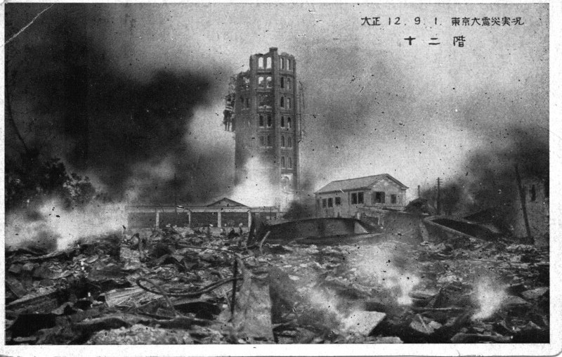
Taishō 12.9.1 Actual Conditions of the Great Tokyo Earthquake: Twelve Stories. |
Disaster is an ever-present, and ever-timely, issue both in Japan and around the world. The triple disaster of 3.11 and its extensive media coverage are a vivid reminder not only of disaster’s critical and catalytic role in history, but the dynamic agency of images in mediating our experiences of natural or man-made events to produce that history. The 1923 Great Kantō Earthquake, which devastated the major cities of Tokyo and Yokohama, as well as five other surrounding prefectures, was one of the world’s worst natural disasters of the early twentieth century. In terms of loss of life and material damage, with an estimated 140,000 deaths and countless homeless, it is still Japan’s worst national disaster. Having marked the 91th anniversary of the quake on September 1st, we have an opportunity to learn anew from the media scale of this catastrophe, how different media produce modes of seeing, understanding, and, eventually, remembering. Only by analyzing contending visual responses within disaster communities and how they are codified into collective memory to form a national narrative can we ultimately understand how major events like the Great Kantō Earthquake-or 3.11-become history.
In the brief excerpt below and the full monograph, Imaging Disaster examines traditional and modern image making practices from the Ansei-era Edo earthquake of 1855 to the wartime media event of the Russo-Japanese war, and then up through the 1923 temblor, the official reconstruction of Tokyo in 1930, and even the atomic bombings of the Asia-Pacific war, to illuminate the intermedia nature of disaster images that all, regardless of medium, process observable phenomena through the imagination, blurring the boundaries between the real and the fantastic. This promiscuous commingling of fact, fiction, documentary, and melodrama to produce the visible evidence of history, reminds us of the inherent scopic pleasure of disaster spectatorship, and how for everything that is made visible in the imaging of catastrophic events, many things are made invisible.
The Indian Ocean tsunami, Hurricane Katrina, the Sichuan and Haiti earthquakes-the experience of disaster is both universal and particular. Most of us understand these horrific events through a complex matrix of media, most of them visual, that attempt to record and ascribe meaning to destruction, chaos, and tragedy. Images mediate our experiences. How the visual functions in relation to disaster, however, requires close critical examination. The visual culture of disaster can produce an exploitative aesthetics of horror and spectacle that transforms viewers into unwitting voyeurs. At the same time, people can use images to reclaim disaster sites for social and political purposes. Images can impart emotional value to an event by humanizing, heroizing, and monumentalizing it. They can also erase or justify aspects of it. Images act on us, or as W.J.T. Mitchell has written, pictures “want” things from us and for themselves.i
Focusing on one landmark catastrophic event in the history of an emerging modern nation-the Great Kantō Earthquake that devastated Japan’s imperial capital and its surrounding areas in 1923-I explore how different media produce modes of seeing, understanding, and, eventually, remembering. Major disasters focus the social energy of diverse media on one critical event. Such moments create a density and intensity of visuality that make them ideal to explore the influence of imaging practices.ii But media do not exist in isolation. As I demonstrate through the excavation of tropes and motifs that circulated widely, visual culture constitutes an intermedia dialogue to which each medium brings a distinct yet critical inflection. In 1923, viewers encountered photography and film, and visualizations of scientific information, alongside hand-rendered prints, paintings, sculpture, and cartoons. They experienced a public visual sphere in which objective and subjective values were inextricably fused. Images played a central role in constructing the earthquake as a national event, rather than simply a local tragedy, that demanded solidarity from all Japanese people. Mass media and new scientific technologies globalized Japan’s tragedy, inviting empathy from the world. Images of disaster erected a framework of visual authority that legitimated the state’s responses to this national catastrophe. Yet the disaster was not the sole preserve of the state. A range of public and private entities, from the imperial household to the leftist avant-garde, used the earthquake to advocate their own visions for the future.
Although proceeding from natural causes, the 1923 earthquake became a metaphor for the relentless destruction of tradition by modernity. For many Japanese, the earthquake recapitulated and accelerated the ruptures and dislocations of modernization, which had been subjects of intense debate long before the temblor hit. The disaster not only crystallized these debates but also demonstrated the fragility of modern society: the greater the technological achievement, the more spectacular its destruction. The shock of the quake became the shock of the modern.
Disaster images do not emerge ex nihilo, however; they are part of a cumulative history of visual production. Images draw from local genealogies and pictorial traditions that include secular and sacred representations. As time goes on, they become imbricated in a global network of image making. My interest in this process, and the images, spaces, and discourses that it produces, has led me to write this book.
Similarly, disaster is not static. It is an unfolding temporal landscape within which visual production must be historicized. In exploring diverse reactions to the Kantō earthquake over time, I identify the multiplicity and changing nature of this traumatic experience for the Japanese. Only by analyzing contending visual responses within disaster communities and how they are codified into collective memory to form a national narrative can we ultimately understand how major events like the Great Kantō Earthquake become history.iii
The Media Scale of Catastrophe
September 1, 1923, has been stamped indelibly on the mind of the Japanese nation, for on that day, at noon, Tokyo and six other prefectures in Kanto were visited by a terrific earthquake, the fire following which devoured hundreds of thousands of houses, destroyed all means of communications, ran up an incalculable death list, created a million and a half refugees, destitute of homes, food, or clothing, and shattered family ties.
Tokyo and Yokohama, the two greatest cities in the districts affected, of whose great buildings and cultural equipment the whole nation has been proud, changed into masses of fire-swept debris, the only remains of the seat of civilization of the Far East.
Japan, however, will not succumb before nature’s ravages; such a day of national calamity marks the beginning of a test of the nation’s stamina.
The Osaka Mainichi has undertaken to publish photographs, taken at great risk and sacrifice by members of the photographic corps of the paper, to enable the readers to realize the damage wrought by the calamity, and supply the public with a costly souvenir of the greatest calamity in the world-a souvenir that can be passed down through the generations.
Foreword to Ōsaka Mainichi Shinbunsha, Kantō shinsai gahō (Kantō Earthquake Pictorial), vol. 1, 15 September 1923
When the Ōsaka Mainichi Shinbunsha published its bilingual three-volume photographic pictorial of the Great Kantō Earthquake just two weeks after the event, the calamity had already been captured in thousands of images that circulated on a national and international media highway. Commercial photographers and photojournalists produced the most abundant and immediate images of the quake, which were transmitted in newspapers, special-issue newspaper pictorials, commemorative photography collections, illustrated survivors’ accounts, and sets of commemorative postcards. These photographic images functioned as both news and souvenirs, rendering their consumers/viewers, inside and outside the devastated locale, into both witnesses and voyeurs. Images in the news media and those issued by respected publishing houses carried the visual authority of supposed facticity. As such they both produced and became the historical record of the event. These photographs also heroized the vision of their producers, who pointed out that they had taken them “at great risk and sacrifice” to assist the world in comprehending the event. Many photodocumentary images quickly went from being indexical to iconic through their repeated reproduction and circulation, even setting the grammar for visual responses in other media such as prints and painting. An intermedia dialogue emerged based on the purported verisimilitude of the photodocumentary as a touchstone for narrating the event, but it revealed the inadequacy of any one medium, including the “realistic” mode of photography, to express the totality of the disaster. I examine how the extensive photodocumentary coverage in the mass media allowed people throughout Japan (and throughout the world) to share vicariously in the plight of Tokyo residents living out a life-and-death drama on the streets of the capital, a supreme example of what Paul Virilio has called “the media scale of catastrophes and cataclysms that dress the world in mourning.”iv I argue that these visual images helped collectively produce the event known as the Great Kantō Earthquake by codifying the tropes and motifs that would form an enduring visual lexicon of disaster. By asserting visual authority, the diverse perspectives of the photographic eye and its technologically mediated vision had an enormous impact on people’s perception of the event. Together with the camera, other scientific and technologized modes of visualization, including cartography and seismography, produced visible evidence to buttress this visual authority. In its social impact, disaster photography embodied a civil contract that forged multilayered power relationships. It simultaneously inscribed and pointed to the limits of visual authority by revealing the heterogeneity of viewing experiences. At a psychological level, the imagery sought to instill national resilience and empathic mourning yet still unavoidably indulged the eye in the perverse pleasures of disaster viewing.
The sublimated iconoclasm of poststructuralism has generated an overwhelming distrust of images and vision in theoretical discourse in the past few decades. And popular cultural theorists such as Susan Sontag have maintained a critical skepticism while acknowledging the power of images to evoke empathy for those touched by calamity. According to Sontag, “Nonstop imagery (television, streaming video, movies) is our surround, but when it comes to remembering, the photograph has the deeper bite. Memory freeze-frames; its basic unit is the single image. In an era of information overload, the photograph provides a quick way of apprehending something and a compact form for memorizing it. The photograph is like a quotation, or a maxim or proverb.… Conscripted as part of journalism, images were expected to arrest attention, startle, surprise.… The image as shock and the image as cliché are two aspects of the same presence.”v Yet the image fatigue of the late twentieth-century visual world of which Sontag spoke grew out of a mass culture that was radically different from that of the 1920s, when photography still retained its spectacular aura for mimetic reproduction and the mass media had been circulating photographic images of disaster globally for only a little over three decades. In 1923, the imaging of disaster ultimately attested to the Japanese nation-state’s survival and its tenacity in the face of adversity. This was highly significant because of the unprecedented, “historic” nature of the catastrophe. In the first few days after the quake, there were rumors throughout Japan and abroad that Tokyo and Yokohama had been completely obliterated. Visible evidence proved otherwise. The cyclical nature of destruction in Japan precluded an apocalyptic vision, even when the nation was seemingly on the brink of total annihilation (this would change in the postwar period after the introduction of the atomic bomb).
The photographic eye is not singular and the print media are not univocal. In fact, the imaging of the Kantō disaster displays a cacophonous world of widely diverging experiences and objectives, perhaps not surprising in a heterogeneous society, although it is not always immediately evident from the many rhetorical efforts to galvanize the populace through a moralistic, unifying discourse of resilience and optimism. Therefore, one must tease out the strands of meaning in these visual representations and ascertain how the visual became imbued with social significance.
Technologies of Seeing and Visible Evidence
Before the advent of popular radio, print news media were the primary means of disseminating information throughout Japan. For the most part, the Kantō quake destroyed all telecommunications like the wireless and the telephone.vi While the publishing industry and the news media were devastated, they recovered quickly.vii At least twelve newspapers were being published in Tokyo at the time, and two of the five major papers, Hōchi shinbun and Tōkyō nichinichi shinbun, were able to resume printing by the fourth day after the quake. Others, such as the Tōkyō asahi shinbun and Yomiuri shinbun, were up and running again by 12 and 15 September, respectively. However, this brief break did not stop the dissemination of information. Although still predominantly a regional business, newspapers from throughout the nation published information about the quake-some fact, some fiction-that streamed out of the capital. There were also numerous public official statements (kanpō) providing updates about the areas of destruction (including regions surrounding the capital), locations of refugee facilities, state of telecommunications and transportation, status of foreign aid, and activities of international dignitaries, such as the American ambassador. Even in the first month after the earthquake, news publications collectively began to parse the visual lexicon of Japan’s massive natural disaster and to codify the tropes that would define it.
Some of the earliest press images of the disaster were from the areas surrounding the capital and ran in Osaka-based news outlets. The coverage indicated how difficult it was for journalists to get close to the center of the devastated region. It marked the sudden stream of attention inward toward the capital and the flow of refugees outward away from the devastation. The Ōsaka mainichi shinbun was one of the first newspapers to publish photographs of the disaster in a special edition. With its reporters unable to reach Tokyo, the newspaper featured scenes of the city of Numazu in Shizuoka prefecture. On the day after the event, the front page pictured large fissures in the ground, a house roof dramatically in ruins, and a close-up of displaced refugees waiting at a train station. The second page featured Osaka residents preparing supplies to send to the stricken region and a pilot boarding his airplane to fly to Tokyo to provide assistance. Subsequent issues had aerial shots of billowing clouds of smoke from the smoldering landmass of the city and ground shots of all aspects of the destroyed cityscape.viii Some formal portrait lozenges were scattered throughout the images of destruction, spotlighting well-known individuals who had perished or been injured in the disaster.
The photographic eye directly affected perception. Aerial photographs of the damaged areas dwarfed the people on the ground, emphasizing the expanse of devastation. Such images inherently express scale and magnitude and speak more of civilizational and urbanistic destruction than of individual lives lost. Photographs of burning land seen at a distance have their roots in the print images of Edo. For example, images in Ansei-Era Observations (Ansei kenmonshi) show Edo from a bird’s-eye panoramic view, highlighting large swaths of billowing smoke rising from the burning city. The new heights achieved in aeronautic technology amplified the vastness of the photographic gaze and further depersonalized the connection between viewer and devastation. They also added a layer of technological mediation, interposing the aircraft as well as the camera. Aerial photography was already an important strategic technology in war and disaster reconnaissance imaging abroad. The “logistics of military perception” developed during World War I, according to Virilio, had as much tactical importance as the timely supply of ammunition. As a “watching machine,” the aerial camera turned the photographic eye into a weapon.ix Moreover, when catastrophe struck, aerial photography became not merely a reproductive technology but also a critical method of disaster management: relief operations benefit enormously from immediate information about the extent of damage and the unfolding destruction and are better able to deploy emergency fire and rescue teams efficiently. Aerial photography is still a critical means of identifying priorities in postearthquake relief operations, providing information for logistical planning and, critically, for determining access routes.x
While drawing attention to the devastating extent of the damage, aerial photography’s commanding view also communicated a controlling gaze in images of the 1923 quake: if the disaster could be presented in its totality, it could somehow be controlled. However, media efforts to establish a commanding vision also articulated the limits of such control as critical sites still in jeopardy remained concealed from view. On the cover of Asahi Graph’s (Asahi gurafu) special pictorial issue “Full Record of the Great Earthquake” (Daishinsai zenki) (fig. 1), which proclaimed itself “the most well-organized record and pictorial report,” a single large official aerial photograph of the burning capital taken by a naval aircraft shows white smoke gusting off the page, obscuring two-thirds of the ground.xi The ordered grid of the city and the pronounced roadways, the only identifiable details from this height, seem about to be consumed by the unstoppable conflagration. The same photograph, reproduced in the Ōsaka asahi shinbun with the caption “Raging fires consuming the imperial capital,” injects the scene with more ominous portent by adding the critical descriptive detail that the white smoke is shrouding the Imperial Palace-the home of the empire’s divine ruler-and thereby calling into question the survival of the nation’s leadership.xii
Some aerial photographs, such as the iconic photograph of the Marunouchi district that ran in the Hōchi shinbun (fig. 2), emphasized the technological mediation of the photographic eye by incorporating the wing of the airplane as a framing device. Such views reinforced both the tremendous expansion of modernity’s vision, literally and figuratively, and its ever more disastrous consequences. Nevertheless, the state again tried to instrumentalize the totalizing vision of aerial film in 1926, when it sought to demonstrate the success of large-scale urban reconstruction in the fifteen-minute film Reconstruction of the Imperial Capital Seen from an Airplane (Kokusen nite fukkō no teito e). (The film was shot by well-known cameraman Shirai Shigeru and produced by the Ministry of Education [Monbushō]).xiii Through movement, film increased the temporal and spatial expansiveness and impact of the aerial vision. Yet while the semblance of totality was useful for the Japanese government, it was deceptive, because no view could encompass the full implications of the event or the ramifications of reconstruction.

Figure 1. Aerial photograph of the burning capital, front page. “Full Record of the Great Earthquake” (Daishinsai zenki), special issue, Asahi Graph, October 1923.

Figure 2. Marunouchi Seen from an Airplane (Hikōkiue kara mita Marunouchi), photograph. Hōchi shinbun, 20 September 1923, A.M. ed., 7. By permission of Yomiuri Shinbun.

Figure 3. Map of Tokyo-Area Fires and Victim Gathering Sites (Tōkyō kasai chiiki oyobi risaimin shūdan chizu), with hatches indicating areas of destruction. Dai Nihon Yūbenkai Kōdansha, Taishō Daishinsai daikasai (The Great Taishō Earthquake Conflagration) (Tokyo: Dai Nihon Yūbenkai Kōdansha, 1923).
Schematic maps of surviving transportation networks, refugee facilities, and the deployment of military personnel throughout the region affected by the quake also visually supported the authority of the state by implying control over a vast area of devastation. Like aerial photography, such maps were a powerful logistical weapon. The detachment conveyed by the scale and magnitude of aerial photography was echoed in the many chillingly clinical geographical mappings of the disaster, which covered the region with red hatches indicating the complete destruction of vast, blighted sections (fig. 3). Many Taishō maps, building on their increasingly detailed late-Edo precursors, were scientifically cartographic, delineating the exact layout of the metropolitan area, and the graphic red hatching overlaid on the schema of the city is utterly dispassionate in marking the decimation of nearly half of its land area, lending visual authority through apparent facticity.xiv The technique of blotting out large areas of the city with red pigment to indicate fire damage was common in late-Edo mapping. For example, it appears in the news kawaraban (broadside) maps of fire-blighted areas of Kyoto destroyed during the Kinmon or Hamaguri Rebellion (Kinmon no Hen or Hamaguri Gomon no Hen) of 1864, when the Tokugawa shogunal forces quashed an uprising by antiforeign imperial loyalists.xv The 1923 maps refined this practice. Yet they are not entirely lifeless, for the small patches of red indicating safe havens for refugees look eerily like blood hemorrhaging across the image.
In photographs, the subtle differences in perspective among elevated and panoramic scenes of the devastated cityscape give hints to the scope of the disaster. Some images visually extended the horizon line of the urban ruins, giving Tokyo the look of a never-ending postapocalyptic wasteland (fig. 4). These open, decimated vistas expose recently inhabited land to the observer and show new views born out of the destruction; where a dense metropolitan cityscape previously blocked the gaze and directed it along the axes of major boulevards, now one’s gaze can extend for miles unobstructed. This new visibility is reinforced through the picturing of areas commonly known for their urban density and large buildings: Nihonbashi, Ginza, Maruouchi, Kanda, and Kyōbashi, for example. In areas where the burned-out carcasses of monumental Western-style edifices remained, the viewer can see through their empty, charred shells into the distance (fig. 5 top). The known scale of these buildings established a visual benchmark for perceiving the magnitude and enormity of destruction, and the transformation of the solid, opaque structures into open screens reiterates the evisceration of the city itself.

Figure 4. Ningyōchō Street (Ningyōchō dōri), postcard, 1923. Ishii Toshio Collection. By permission of Japan Publishing Copyright Association.

Figure 5. The Burned Expanse toward Ginza That Looks like Ruins (Haikyo no yōna Ginza hōmen no yakeato) (aerial view, top); Burned Skeletal Remains of Trams and Cars Lying across the Road (Zankotsu o romen ni yokotaeta densha to jidōsha) (ground view, bottom), photographs. Ōsaka Asahi Shinbunsha, Daishinsai shashin gahō (Photographic Pictorial of the Great Earthquake), vol. 2 (Osaka: Ōsaka Asahi Shinbunsha, 25 September 1923), 9.

Figure 6. Ginza Street (Ginza dōri), showing a lonely figure on the once-fashionable boulevard, postcard, 1923. Ishii Toshio Collection. By permission of Japan Publishing Copyright Association.
In contrast to the aerial images, photographs taken from a ground perspective invited the viewer to identify with figures making their way through the treacherous rubble (fig. 5 bottom). These images reduce the city to human scale, thereby acquiring emotional resonance and allowing the viewer to identify with the plight of the survivors. In one photograph (fig. 6), a single male figure holding an umbrella and walking away into the murky distance amid the ruins of the formerly fashionable Ginza district imbues the scene with pathos. Such images of the city carry a tragic irony in their contrast with the myriad familiar images of well-dressed ladies and gentleman sauntering down the elegant commercial boulevards of the Ginza, Tokyo’s equivalent of the Champs-Élysées in Paris or Fifth Avenue in New York. The popular leisure activity of “strolling in the Ginza” (a practice known as ginbura), past its fashionable shops and department stores, is profoundly transformed in these photographs; clearly there was no window-shopping to be done here. Postquake ginbura was a promenade through ruins.
The Postcard Album as Visual Archive
To supplement the excerpt above, I would like to offer a close-up view of a valuable visual archive for disaster: the postcard album. After the Great Kantō earthquake there was a booming market for disaster postcards. News was often indistinguishable from souvenirs, and the same photographs were widely circulated in the form of commemorative postcards, often sold in sets. Postcards were introduced to Japan in 1873 with the new national postal system. They were a vivid symbol of Japan’s modernity, marked by the inauguration of a new communications system in the Meiji period. Already a very popular medium for depicting scenes from the Russo-Japanese War (1904–5), postcards of natural disasters were commonplace in Japan by the time of the 1923 quake. Extant envelopes for sets indicate that Kantō earthquake postcards were produced far and wide, from Hakata on the southern island of Kyushu to Osaka in the western Kansai region. Printed in collotype, offset, and gravure, many photographic postcards, along with original photographic prints, were commissioned by Tokyo publishers (hanmoto), which had been burned out of business but recognized the potential profit in earthquake images. Hundreds of varieties of postcards were issued. Publishers sold most of them on the street, and many of the images sold out quickly. The intimate, pocketsize format of the postcard lent itself to personal consumption. Since the vast majority of 1923 disaster postcards that survive have no writing on them, they were likely treated more as collectibles than as a form of postal communication. Many were put into albums, creating new ways to combine images and create visual cultures of disaster for home viewing. Accordion-style albums, such as the example pictured here, allowed for personalized, serial organization of images that produced unique, imagistic narratives of the event. The album pages were also two-sided and could be stretched out to view a series of images on recto and verso (fig. 7). These miniature collections form individual archives that provide vivid windows into the earthquake viewing experience.

Figure 7. Example of a postcard album. |

Figure 8. The Actual Wretched Conditions of the Great Tokyo Earthquake: Ginza Street seen from an Airplane.

Figure 9. Metropolitan Police Department and the Imperial Theater in the Ferocious Flames
Postcards mirrored the photographic eye in the pictorial volumes, surveying the damage both from distant aerial perspectives (fig. 8) and from the ground (fig. 9). However, they often distinguished themselves through the widespread addition of color, which was thought to enhance the verisimilitude while aestheticizing the image. Although still photographs could not capture the spectacle of the quake in real time, hand or machine application of color tinting to black-and-white images that were mass printed sought to provide an immediacy and layering to the otherwise largely static scenes. The dynamic “ferocious flames” (mōka) were added to photographic postcards to lend movement to the images, yet the stillness of the pictures speaks of an inability to reenact the event in a temporal or visceral way; rather, it reinforces the irretrievability and distance of history. Similarly, images of streets engulfed in flames, tinted to communicate imminent danger and terror, are perhaps more striking because of their inability to convey the true nature of the experience.

Figure 10. Taishō 12. 9. 1 (Great Tokyo Earthquake) Pitiful Azumabashi Bridge Destroyed by Fire and Before the Quake.

Figure 11. Corpses lined up for identification after the earthquake

Figure 12. Taishō 12, 1 September, 11:58a.m. Great Tokyo Earthquake Yoshiwara.
Other postcards make the before-during-and-after temporal frame of the disaster explicit by superimposing inset photographs of famous sites before their spectacular destruction such as seen in this dramatic pair of images showing the fate of Azumabashi bridge in Asakusa violently twisted by the temblor and engulfed in flames (fig. 10).
Photographic representations of mass carnage were repeated throughout the locales of the city, particularly in postcards, emphasizing the widespread loss of life, capitalizing on the tragedy, and inflaming public sentiment (fig. 11). The voyeuristic relationship between the viewer and the image, the living and the dead, is thrown into greater relief in a widely circulated news and postcard image of the pond in the Shin Yoshiwara licensed prostitution quarter (fig. 12), where thousands of women who worked in the brothels perished, unable to get out of the gated district. Like many victims throughout the city who sought refuge from the fires in the extensive waterways of Tokyo, numerous women of Yoshiwara drowned or were literally boiled alive when they fled into the district’s large pond Benten ike.

Figure 13. (Taishō 12, 1 September) The Great Kantō Earthquake: Great Chaos of Refugees in the Vicinity of Ueno Station.

Figure 14. Taishō 12. 9. 1 Actual Conditions of the Great Tokyo Earthquake: Nippori Train Station. Refugees on the platform trying to flee the city.

Figure 15. (Taishō 12, 1 September) Wretched Conditions of the Great Tokyo Yokohama Earthquake. Refugees at Ueno Hirokōji.
Images of refugees focused on oceanic crowds fleeing the destruction and raging fires (figs. 13-14), and on more intimate, sympathetic portraits of family groups, particularly mothers and children, gathered in temporary shelters (fig. 15).
Notes
i W.J.T. Mitchell, What Do Pictures Want? The Lives and Loves of Images (Chicago: University of Chicago Press, 2005).
ii I use the term visuality here to indicate “the social construction of the visual field, and the visual construction of the social field,” reciprocal processes that structure the subjectivity and agency of the viewing public. W.J.T. Mitchell, “Responses to Mieke Bal’s ‘Visual Essentialism and the Object of Visual Culture’ (2003): The Obscure Object of Visual Culture,” Journal of Visual Culture 2, no. 2 (2003): 252. For an expanded discussion of visuality and visual studies, see Mitchell, “Showing Seeing: A Critique of Visual Culture,” Journal of Visual Culture 1, no. 2 (August 2002): 165-81.
iii Collective memory tends to reflect master narratives of an event forged by leading social and political groups to become “dominant memory.” Daniel J. Sherman, The Construction of Memory in Interwar France (Chicago: University of Chicago Press, 1999), 7.
iv Paul Virilio, Unknown Quantity (London: Thames & Hudson; Paris: Fondation Cartier pour l’art contemporain, 2003), 63.
v Susan Sontag, Regarding the Pain of Others (New York: Farrar, Straus and Giroux, 2003), 22–23.
vi The earliest information about the disaster was sent by wireless from survivors on ships moored at Yokohama. This information was relayed throughout the country and abroad through the heroic efforts of local telecommunications operators in regional stations throughout Japan, particularly the operator at the Iwaki wireless station in Fukushima. The Kantō earthquake dramatically demonstrated the importance of wireless for national security, and Japan’s experience convinced many governments to fund the technology as a priority mode of telecommunications. Joshua Hammer, Yokohama Burning: The Deadly 1923 Earthquake and Fire That Helped Forge the Path to World War II (New York: Free Press, 2006), 178–88.
vii Shinbun Shiryō Raiburarii, Kantō Daishinsai (Great Kantō Earthquake), vol. 1 (Tokyo: Ōzorasha, 1992).
viii Because of the difficulties getting access to the devastated Kantō region, aerial reconnaissance was critical in relaying information about the nature and extent of damage to coordinate external relief operations. The Japanese army flew these missions out of its base in Nagoya. J. Charles Schencking, “1923 Tokyo as a Devastated War and Occupation Zone: The Catastrophe One Confronted in Post Earthquake Japan,” Japanese Studies 29, no. 1 (2009): 117n35.
ix Paul Virilio, War and Cinema: The Logistics of Perception (London: Verso, 1989), 1–3, 11.
x Illah Nourbakhsh et al., “Mapping Disaster Zones,” Nature 439, no. 7078 (2006).
xi “Daishinsai zenki” (Full Record of the Great Earthquake), special issue, Asahi Graph, October 1923; Nihon Shinbun Hakubutsukan, ed., Daishinsai to hōdō-ten: Kantō daishinsai 80-shūnen kikaku (Exhibition of the Great Earthquake and the News: Plans for the 80th Anniversary of the Great Kantō Earthquake)(Yokohama-shi: Nihon Shinbun Hakubutsukan, 2003), 29.
xii Ōsaka Asahi Shinbunsha, Daishinsai shashin gahō (Photographic Pictorial of the Great Earthquake) (Osaka: Ōsaka Asahi Shinbunsha, 15 September 1923), 1:3.
xiii Shirai Shigeru (cameraman), Reconstruction of the Imperial Capital Seen from an Airplane (Kokusen nite fukkō no teito e) (Tokyo: Ministry of Education, 1926). Kamera to jinsei: Shirai Shigeru kaikoroku (Camera and Life: The Memoirs of Shirai Shigeru), (Tokyo: Yuni Tsūshinsha, 1983), 51–58.
xiv Edo-period earthquake maps were predominantly topographical maps that communicated the location of fires or schematic maps of the layout of the city around the shogunal castle that had arrows indicating the direction of fires, which were called “direction marker maps” (hōkaku-zuke). Tōkyō-to Edo Tokyo Hakubutsukan Toshi Rekishi Kenkyūshitsu, Kantō Daishinsai to Ansei Edo Jishin (The Great Kantō Earthquake and the Ansei Edo Earthquake), Tōkyō-to Edo Tokyo Hakubutsukan Chōsa Hōkokusho, vol. 10 (Tokyo: Tōkyō-to Edo Tōkyō Hakubutsukan: Tōkyō-to Rekishi Bunka Zaidan, 2000), 41, 190; Kinoshita Naoyuki et al., Nyūsu no tanjō: Kawaraban to shinbun nishikie no jōhō sekai/The Birth of the News, Visual Media in 19th-Century Japan, Tōkyō Daigaku korekushon (Tokyo: Tōkyō Daigaku Sōgō Kenkyū Hakubutsukan, 1999), 162–63, 78–79; Miyata Noboru and Takada Mamoru, Namazu-e: Shinsai to Nihon bunka (Catfish Pictures: Earthquakes and Japanese Culture) (Tokyo: Ribun Shuppan, 1995), 78–79.
xv Kinoshita et al., Nyūsu no tanjō, 175–77.